US and Canadian Camdens
Lord Camden and America
“No taxation without representation.”
As a member of the House of Lords, Charles Pratt, 1st Earl Camden, was an outspoken supporter of the American colonists. Deep in debt in the 1760s, Britain imposed a series of taxes, designed to fund the colonial administration in America and to pay for the large number of British troops stationed there. The Stamp Act of 1765 imposed a tax on all legal and official papers, and publications and playing cards in the colonies; it was so unpopular among the colonists that it was quickly repealed. In his maiden Lords speech in 1766, Camden argued that taxation was founded on consent: there should be no taxation without representation. He was one of only five Peers to vote against the Declaratory Act, a resolution confirming Britain’s absolute right to impose taxes on the colonies. Also opposed by Lord Camden was another raft of taxes, on such imported essentials as paint, paper, glass, lead and tea, which had caused further resentment in America and led to violence.
In the 1770s, with the Whigs in opposition to Lord North’s Tory government, unrest increased. In the Boston Tea Party in 1773, the ‘Sons of Liberty’, some disguised as Native Americans, boarded East India Company ships and tipped a whole consignment of imported tea into the harbour. In retribution, Parliament passed a number of Coercive Acts, which inter alia closed Boston harbour until the lost tea was paid for, forced colonists to quarter British troops on demand, and ended the free election of town officials. Lord Camden, who naturally opposed the measures, as ever condemning the taxes that had caused the unrest, was embarrassingly reminded that he had been Lord Chancellor when they were imposed. Though the punitive Coercive Acts were meant to quell rebellion, they had the opposite effect, and 1775 saw the outbreak of the American War of Independence, to the dismay of Lord Camden who favoured conciliation and negotiation. In his Lords speech on the crisis, thought to have been written in collaboration with Benjamin Franklin, he had said:
“My lords, it is evident that England must one day lose the dominion of America. It is impossible that this petty island can continue in dependence on that mighty continent … To protract the time of separation to a distant day is all that can be hoped.”
While strongly opposing the use of force to subdue the colonists, Camden did not favour independence and was unhappy when it occurred. Though he never visited America, his reputation there as a champion of colonists’ rights led to many places, scattered across the country, being named or renamed Camden, directly or indirectly in his honor.
We are about to begin a tour of them (US places arranged alphabetically by State). Population figures are the latest available..
United States
Camden, ALABAMA
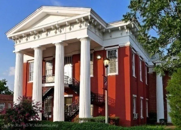
Wilcox County Courthouse
City in and county seat of Wilcox County; population 1,900 (est.), elevation 63 m / 206 ft. Contribution from Wilcox Historical Society.
By Daniel Fate Brooks
Thumbing the pages of Alabama history, one soon learns that the Wilcox County seat of Camden is greatly enriched by the Alabama River and other natural resources. The town, located in a bend of the river, lies on the edge of a distinct prehistoric and geological sub-region which gives rise to the twelve-county fertile crescent known as the Alabama Black Belt. From the many examples of antebellum architecture in the area, this land of rich soil brings to mind mid-nineteenth-century wealth and greatness, and also a culture and civilization that continue to shape state and national politics, history, art, tradition and lore.
Wilcox County, founded in 1819, and one day older than the state of Alabama, is the southernmost county within the Black Belt region. From its first year of existence the county attracted aristocratic settlers from Virginia, the Carolinas and beyond. These immigrants brought with them enslaved labor but created a sense of culture and high-level of gentility which rapidly transformed a frontier wilderness into settlements reminiscent of their previous home states. Along the banks of the Alabama River, ports and towns sprung up under the names of Black’s Bluff, Lower Peach Tree, Prairie Bluff and Canton. Inhabitants revealed in their connection to Mobile, but from the onset, suffered from the perils of disease plaguing their communities. In 1830 Wilcox Countians, including the populace of Canton, the first county seat, joined the citizens from eastern villages in their cravings for a center of government that was not only more healthy but also more centrally located.

The Wilcox Female Institute
By the fall of 1832 Thomas Dunn and his wife, Martha Hobbs, had donated twelve acres of wooded land in the center of the county for a new seat of government. The spot, four miles from the river, was rich with springs, providing an ideal location for its designated purpose. In swift succession the community, first called Wilcox Courthouse, grew and was soon established and renamed Barboursville. Influential Virginia immigrants selected the name to hono*r Philip Pendleton Barbour, Virginia native and tenth Speaker of the U.S. House of Representatives. The little town quickly swelled, attracting more settlers from the south Atlantic seaboard. In time an unusually large influx of small farmers and a powerful and wealthy planter elite from South Carolina filtered in to create a small version of the Palmetto State. This mix of inhabitants, combined with slave labor, produced a prosperous though highly imperfect plantation society. Among these newcomers was Dr. John Daniel Caldwell, a cousin of John Caldwell Calhoun, the forceful South Carolina Senator and U.S. Vice President. In 1841, Dr. Caldwell, a physician and politician, proposed incorporation and the idea of renaming the town for Camden, South Carolina . Caldwell’s suggestions were overwhelmingly approved by the citizens who admired his brilliant and passionate cousin.
Camden, Alabama adopted a South Carolina form of government, with the chief magistrate of the town serving as Intendant instead of mayor. The title of Intendant, derived from the French, was used by the city of Charleston and other South Carolina towns where the office was assisted by wardens. A wide thoroughfare in Camden was named for Calhoun. Picket fences flowed in front of vernacular and classical styled homes spaced at intervals and surrounded by trees. Camdenians were proud to live in the new county seat, but they were equally proud of binding ties to the state of South Carolina.
Besides the immigrants from the south Atlantic seaboard, others came as well: English, Scotch, Irish, German, French and a young saddler who migrated from the Italian Alps. Jewish merchants owned businesses alongside their Christian counterparts, and all contributed to the polyglot blend of cultures, giving Camden a remarkable and cosmopolitan identity. From the 1830s to the outbreak of the Civil War, hundreds of enslaved Africans were delivered by traders from the markets in Montgomery. In 1860 the Black population of Wilcox County numbered almost 18,000 to a White populace of less than 7,000. The census that year listed over 800 individuals as “mullatto” and recorded 26 as “free colored.”
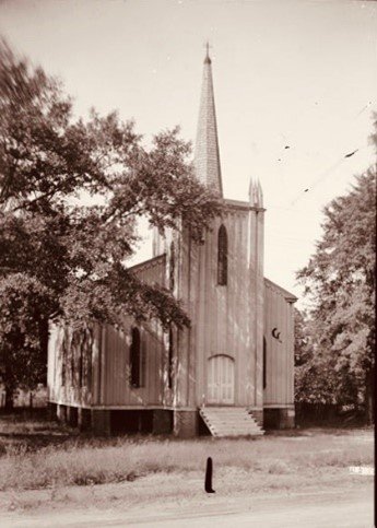
St Mary's Episcopal Church
As wealth increased, the town’s economic success resulted in a zeal for academic and religious pursuits. Classical education molded the minds of many Camden children, yet few schools had the influence of the Wilcox Female Institute. The school’s catalog boasted not only the advantages of Camden’s location, but it also touted an extensive curriculum in both the arts and more practical education. For many patrons, the beloved Institute was forever an academy of the “first rank.” The brick Greek Revival building housing the Institute remains one of the town’s most significant landmarks, along with two church buildings, the monumental Greek Revival Courthouse and Dale Lodge, home to one of Alabama’s oldest Masonic orders. These structures have witnessed not only the days of cotton but also Civil War, slave emancipation, radical Reconstruction and other difficult times and events.
It goes without saying that Camden is a historic town. Yet underlying the enduring nature and success of the community have been an unfaltering pride, self-respect and an evolving belief that despite differences, its history, both positive and negative, is as defining as the rich soil, the wealth of natural resources and a close proximity to the river.
In an era in which large cities and more complex metropolitan areas dominate, it speaks well that Camden, Alabama, a town with a population with fewer than 2,000 in 2022, can take pride in claiming a history of notable sons and daughters, both African American and White. The list is long, but it is important to recognize Hank Aaron, the great American baseball player; Kay Ivey, current Governor of Alabama; Emmett Kilpatrick, an interpreter at the Versailles Peace Conference and a prisoner of the Bolsheviks; and Jeff Sessions, the 84th U.S. Attorney General and U.S. Senator.
Today people from all walks of life are drawn to the microcosm of Camden and Wilcox County, Alabama. Many come to hunt, fish and enjoy the river. Others tour and view the historic architecture and marvel at a recent resurgence of business and renovation. Most visitors quickly develop a genuine respect for this small and intriguing Black Belt town.
Port Camden, ALASKA
In south-eastern Alaska, 35 miles west of Petersburg
Port Camden is a body of water 16 miles long on the east coast of Kuiu Island. It was named on 4 August 1794, ‘probably’ in honor of Charles Pratt, Earl Camden’, by Captain George Vancouver, RN. It happened towards the end of a five-year expedition during which he had both circumnavigated the globe and charted North America's north-western Pacific Coast as far north as Alaska.
Camden Bay, ALASKA
In northern Alaska on the Beaufort Sea coast between Barter Island and Point Brownlow; 50 miles wide
The bay was named on 4 August 1826, by Captain John Franklin, who had travelled to the region overland from Canada. He wrote:
“We embarked … to cross the bay, which has been named in honour of the Marquess Camden”.
Knighted in 1829, Franklin was to serve for six years from 1837 as Lieutenant Governor of Van Diemen’s Land (Tasmania). He is, however, now chiefly remembered for his ill-fated final naval expedition to the Arctic in 1845, to complete the charting of the Northwest Passage. His two ships became icebound in what is now Nunavut, and over ten months he and his entire crew perished, whether from starvation, hypothermia, scurvy, or botulism caused by badly canned food. Eventually, more men and ships were lost in searching for Franklin than in the expedition itself. Though he had no personal connection with Camden Town (London), his wife Lady Jane Franklin was born within the modern Borough of Camden in Bloomsbury. A cul-de-sac in Kentish Town within the borough was named Franklin Street in his honour, but later renamed Arctic Street. Back in 1801, as a young midshipman, John Franklin had sailed to Australia under his cousin (by marriage)
Matthew Flinders – coincidentally the mentor of Phillip Parker King, the namer of Camden Bay in Western Australia; and in 1804, by another coincidence, he was midshipman aboard a ship named Earl Camden.
Camden, ARKANSAS

Downtown Camden, AR
City in and county seat of Ouachita County; population 10,369, elevation 62 m / 203 ft
The city is situated about 100 miles south of Little Rock, on bluffs overlooking the Ouachita River. In 1782 a Spanish military post was established on the site of an old French trading post called Écore à Fabri, or Fabri’s Bluff. By the time Arkansas attained statehood in 1836, indigenous peoples such as the Quapaw and the Caddo had been driven westwards into the future state of Oklahoma.
When in 1842 Ouachita County was carved out of part of Union County, Écore à Fabri was chosen as the county seat, and its name was changed to Camden at the suggestion of Thomas Woodward, one of the commissioners. Soon to be the second largest city in Arkansas and known as the ‘Queen City’ of the Ouachita, Camden became a bustling river port served by frequent scheduled steamboats carrying passengers and freight.
In 1864, during the Civil War, the ‘Camden Expedition’ was the last phase of the US Army’s Red River Campaign. Camden was occupied by Union troops but then retaken by the Confederates. Having also become a railroad town, served by three lines, the town remained an important cotton shipping depot through the early decades of the 20th century. During the South Arkansas oil boom of the 1920s, its economy thrived, and in 1927 the International Paper Company built a processing mill at Camden. During World War II, Camden was home to a training field for US Army Air Forces pilots, which in 1944 became a naval ammunition depot. The site later became an industrial area housing some major defense establishments and creating many jobs. The 1990s, post-Cold War downsizing of the defense industry, and the closure of the paper mill a few years later, resulted in job losses and population decline; but the development of diverse small business and professional activity have since stabilized the town's economy.
L C (‘Buckshot’) Smith, a Black police officer in Camden, was celebrated in 2022 as America's oldest active-duty officer, at the age of 93. Sources: the website of the Ouachita County Historical Society and Wikipedia.
Camden, Fresno County, CALIFORNIA
Unincorporated community; elevation 72 m / 236 ft
Located in central California, 3½ miles east of Riverdale. A post office operated there from 1903 to 1904. Riverdale was originally called Liberty Settlement but was renamed owing to its proximity to the Kings River.
Camden Park and Camden Passage, Sacramento County, CALIFORNIA
Two modern residential neighbourhoods in Elk Grove, just south of Sacramento, the state capital.
Camden, COLORADO
Populated place in Morgan County; elevation 1,277 m / 4,193 ft
Approximately ¾ mile (1¼ km) above sea level, Camden lies on the Grand Army of the Republic Highway (US Route 6).
Camden, DELAWARE

Camden Friends Meeting House of 1805 (photo: smallbones 2014)
Town in Kent County; population 3,529; elevation 12 m / 39 ft
The history of the community can be traced to the 1780s, when members of the Quaker Mifflin family began dividing their lands into lots. Much of this land was originally a part of a 600-acre tract that was granted to Alexander Humphreys in 1680. He named it Brecknock, presumably after the Welsh county. (This was a strange coincidence: over 130 years would elapse before John Jeffreys Pratt adopted Earl of Brecknock as a subsidiary title.) A milling operation was established here in the 1740s. located at the intersection of two important thoroughfares, and a number of homes and businesses were soon constructed.
Daniel Mifflin named it Piccadilly, but it was commonly referred to as Mifflin's Crossroads. The name ‘Camden’ first appeared in 1788, but probably did not replace ‘Mifflin's Crossroads’ in common usage until the end of the century. The town of Camden was firmly established by the 1790s. It became a commercial centre, sending most of its products to market by way of Port of Lebanon, and later by rail with the coming of the railroad in the 1850s. Camden was first incorporated in 1852, and again in 1969. Source: Camden Delaware website
Camden County, GEORGIA

Camden County Courthouse, Woodbine (photo: Ebyabe, 2011)
Population 54,7689, area 2,025 / 782 sq mi
Camden County lies in the southeastern corner of the state of Georgia. Woodbine is the count seat and St Marys the largest city. It is one of the original counties of Georgia, created on 5 February 1777 and named after Charles Pratt, 1st Earl Camden.
The first recorded European to visit what is today Camden County was Captain Jean Ribault in 1562, sent out by French Huguenots to find a suitable place for a settlement. The rivers he saw – known today as the St Marys and Satilla Rivers – he named the Seine and the Some. He described the area as the “fairest, fruitfullest and pleasantest of all the world”.
In 1565, Spain sent out a large force to take over and settle the area. At least two Spanish missions operated on Cumberland Island (off the Camden County coast). attempting to convert to Catholicism the Timucuan people, who had lived on the island for at least 4000 years. Competing British and Spanish claims to the territory between their respective colonies of South Carolina and Florida was a source of international tension, and the colony of Georgia was founded in 1733, in part to protect the British interests. In 1765, four parishes were laid out between the Altamaha and St Marys Rivers. Two of the parishes, St Marys and St Thomas, were formed into Camden County in the Georgia Constitution of 1777.
The main economic enterprise of the county was rice planting, particularly along the Satilla River. Sea Island cotton was grown on Cumberland Island, and short-staple cotton on the mainland along with sugar cane. Various forest products including timber and turpentine were produced, and a shipyard and shipping center developed around the town of St Marys. The land in Camden County was owned by fewer than 300 people. Most of the White population worked in trades or as tenant farmers, while nearly all Black residents were enslaved. The county was the site of many trading posts with the Native Americans, who by the late 18th century were mainly of the Creek Nation. There was significant conflict between settlers and indigenous peoples, leading to a small series of local wars.
In January 1815, British troops led by Sir George Cockburn landed on Cumberland Island. Quickly overwhelming the small American forces, they occupied the county through February. The British occupation of Camden County led to the liberation of an estimated 1,485 enslaved people from Georgia and Florida. At the beginning of the Civil War, the population was 5,482 of which 1,721 were White. During the war, many of the county's civilians moved farther inland. The inhabitants' fears were realized when the town of St Marys was attacked by the United States Navy. At least one federal party to ‘carry off’ enslaved people was met by armed resistance on White Oak Creek off the Satilla River. The first railway in the area was the Savannah-Jacksonville line constructed through Camden County in 189 by the Florida Central & Peninsular Railroad. In 1923 the county seat was moved from St Marys to Woodbine, a reflection of the shift from water transportation to railways. In 1927 US Route 17 was constructed through Woodbine and Kingsland.
From 1917 to 1937 a pogy plant producing oil and fertilizer was one of the major economic activities of the area. The layoffs from the plant found relief when the Gilman Paper Company came to the county, opening a paper mill at St Marys in 1941. By the 1970s, itproduced 900 tons of paper a day and employed up to half of the city’s inhabitants. The company was sold to Durango Paper Co. in 1999, which went out of business in 2002 with the loss of 900 jobs. In 1954 the US Army began to acquire land south of Crooked River to build a military ocean terminal to ship ammunition in case of a national emergency and in 1976 the Kings Bay was selected for a naval submarine base. Camden County's population grew enormously after the military took an interest in the area, and during the 1980s was the fourth fastest growing county in the United States.
Cumberland Island National Seashore was established in 1970 to protect and preserve the natural and historic resources of the island, followed by the Crooked Rover State Park in 1985. In 2012, the Camden County Joint Development Authority began considering developing a spaceport for both horizontal and vertical spacecraft operations, A decade later the Spaceport Camden project was described as still ‘mired in controversy’. Source Wikipedia.
Camden, ILLINOIS
Village in Schuyler County; population 62; elevation 183 m / 600 ft
Written in 1908: “Camden Township, traversed from north to south by Crooked Creek and intersected by the minor streams of Cedar, Brushy, and Missouri, has a varied topography that includes low alluvial bottoms, upland plains and heavily timbered sections, but withal it is one of the most prosperous communities in the country, and its romantic history dates back to the year 1829, when the first permanent settlement was made within its border.
In the fall of that year John and Robert Brown and their brother-in-law, Luke Allphin, of Morgan County, made their first trip to Schuyler County, crossing the Illinois River at Beard's Ferry, now Beardstown, and pushing on westward past the settlements in Rushville and Buena Vista Township, to what is now Camden Township, where they settled on Sections 17 and 20. Here they made rude improvements in the wilderness, and the following spring the families of the three men were removed from Morgan County, where they had made their home since leaving Kentucky. …
The village of Camden, which is situated on the southwest quarter of Section 17, was laid out by Robert Brown and Joseph N. Ward, January 28, 1831, and was surveyed and platted by Samuel McHatton, Deputy County Surveyor. The first store was established in the village in 1838 by John and Joseph N. Ward, and the following year Camden was made a government post office, and Alexander McHatton was named as the first government official. David Campbell built a flouring mill in the village in 1856, and it was operateduntil recent years. Today [1908] Camden is a flourishing inland village, with good schools, churches and mercantile houses, and her citizens are looking forward to the time when they can be put into closer touch with the outside world through the agency of an electric railroad. The population of Camden Township, according to the census of 1900, was 1,278.”
Excerpted from Historical Encyclopedia of Illinois and History of Schuyler County, 1908, edited by Howard F. Dyson; transcribed by Karl A. Petersen for Schuyler County IL. Historical excerpt here. Copyright 1999-2006 Judi Gilke.
Camden, INDIANA

Jackson Township Public Library and Museum
Town in Carroll County; population 589; elevation 205 m / 673 ft
Contribution from Carroll County Historical Society
Excerpt from the booklet Town of Camden
“Located in Jackson Township, which was sold in 1830 for $1,500. Sixteen acres were reserved for laying out a town plat. Early on, John Snoeberger ran a post office in his home a mile west of what is now the town. He named the post office "Camden." At that time, the postal service was responsible for naming the town. Camden was originally laid out as a row of buildings on either side of a dirt road. By 1832 it had five buildings. The nickname of "Stringtown" came about in 1837 because it had only one street. Since then, there has been growth and more streets have been created. Camden has remained small and at its peak had just a little over 800 residents. Many of the larger businesses that once were in Camden have closed down as their owners passed on with no one to take over. It is still a quiet place to live. People know one another and take care of each other. Many of the families have long genealogical roots in the area. Settlers came here from Pennsylvania and Ohio in the late 1820's and early 1830's, and old family cemeteries attest to them being the first non-Indian owners of the land.”
Camden, MAINE

Aerial view of Camden, ME (photo: King of Hearts, 2021)
Resort town in Knox County; population 5,232 (tripled in summer), elevation 63 m / 207 ft
The Penobscot Nation, who have lived in the area for thousands of years, called it Megunticook, meaning “the swelling ocean”. Settlers were here as early as 1768, squatting on Penobscot land and attempting to farm the inhospitable terrain. The first home in the area, a Cape Cod-style house, was built in 1770. The settled area was variously known as the Megunticook or Cambden (sic) Plantation, the latter name in honor of Charles Pratt, Lord Camden. On 17 February 1791, the General Court of Massachusetts approved ”an act to incorporate the Plantation of Cambden, [then] in the county of Hancock into a town by the name of Cambden”; the intrusive ‘b’ was soon dropped.
During Camden’s first century, the town’s population grew steadily (to 4,512 in 1870) and its economy prospered. The Megunticook River provided water power for sawmills and gristmills. By 1858 the town had carriage factories, sash and blind factories and blacksmith shops. There were six shipyards, launching up twelve vessels annually. By 1886, Camden also made foundry products, railroad cars, woolens and paper mill feltings, anchors, wedges, plugs and treenails, planking, powder, powder kegs, mattresses, tinware, oakum, wool rolls boots and shoes, leather, flour and meal, corn brooms and barrels.
Camden had initially embraced Goose River Village on the opposite side of the river, noted for its ice harvesting and manufacture of lime. In 1852, Goose River citizens voted to change their village's name to Rockport (for its rocky terrain); and in 1891 Rockport officially separated from Camden as the result of a dispute over the cost of building a bridge. In November 1892, a fire burned Camden’s business district to the ground. Local businessmen quickly rallied to make the investment required to build 12 large brick buildings, including the Camden Opera House (1894) and, controversially, the Masonic Temple (1893, now the Lord Camden Inn hotel).
In the 1880s, sportsmen and "rusticators" had begun to discover the natural beauty of Camden, becoming seasonal residents in the summer and fall. In 1897 a road was built to the top of Mount Battie, one of the two mountains rising above the town, and an inn was erected at the summit Thereafter, the summer colony at Camden quickly grew to include some of the wealthiest families in the USA, who built large, rambling Shingle-style "cottages". In 1897 a road was built to the top of Mount Battie, one of the two mountains rising above the town, and an inn was erected at the summit. The next year, a group of wealthy summer residents from Philadelphia established the Megunticook Golf Club. The incomers were generous towards the town itself, contributing much to its further development. Land for the Camden Public Library, opened in 1924, the Harbor Park and the Amphitheater beside the library (both 1931), were gifted by Mary Louise Curtis Bok Zimbalist, a local philanthropist.
Still active today is the Camden Yacht Club, founded in 1906. The town also has a large fleet of tall-masted schooners called Windjammers, a legacy of Captain Frank Swift who started his leisure cruise schooner business in the 1940s. Music and cultural interests have long flourished in Camden. Edna St Vincent Millay (1892-1950), the poet and playwright and future Pulitzer Prize winner, grew up in Camden. In 1929 the French harpist Carlos Salzedo founded the internationally renowned Salzedo Summer Harp Colony of America, and each summer held a Harp Festival in the Amphitheater. In the 1950s, artists and writers of significant reputation began moving to Camden and Rockport, where Maine Coast Artists was organized. The movies Carousel (1956) and Peyton Place (1957) were filmed in Camden, which has since served as the locale for many other films.
In 1965 a road was built through Camden Hills State Park (established in 1947) to the top of Mount Battie, enabling expansive views of Penobscot Bay. Camden’s economy boomed in the 1990s when the world's largest independent issuer of credit cards, the since defunct MBNA, located their offices in the former Knox Woollen Mill building, restoring it and generating hundreds of jobs. Through the 20th century Camden had gradually developed into a summer vacation destination, tourist hotspot (and retirement community) that it remains today. Each year the town hosts some internationally renowned annual events: the Camden International Film Festival, founded in 2005 and focusing on documentary film; the Camden Shakespeare Festival; and the Camden Conference, fostering discourse on global issues. While in February the US National Toboggan Championships are held in the town-owned Camden Snow Bowl. 21st-century, Camden has a strong economy, provides diverse educational and cultural opportunities and fosters a strong sense of community.
Founded in 1938, the Camden-Rockport Historical Society maintains the Conway Homestead Museum, comprising six refurbished or reconstructed historic buildings. Further source: Wikipedia.
Camden, Salisbury, MARYLAND
Neighborhood in the city of Salisbury, Wicomico County; elevation 7 m / 23 ft
The Camden Historic District is centered around Camden Avenue and is roughly bounded by the Wicomico River to the north.
Camden Station and Yards, Baltimore, MARYLAND

Camden Station, at the intersection of South Howard and West Camden Streets. was originally built beginning in 1856, continuing until 1865, by the Baltimore & Ohio Railroad as its main passenger terminal and early headquarters. In February 1861, Abraham Lincoln transferred from the President Street station to the Camden Station on his way to Washington DC to be inaugurated as President; and on 18 November 1862 he changed trains at Camden Station, en route to Gettysburg, Pennsylvania to deliver his famous Address. Lincoln also used Camden Station on 18 April 1864 when he made an overnight visit to Baltimore for a speaking engagement. A year later, at 10 am on 21 April 1865, the assassinated president's nine-car funeral train arrived at Camden Station, the first stop on its slow journey from Washington to Springfield, Illinois.
In July 1877, Camden Station was the site of riots and clashes between the Maryland National Guard and strikers during the Great Railroad Strike of that year. Some in the crowd attempted to set fire to the station and nearby buildings. but were largely unsuccessful. Only the station’s platforms remain in use today, by both local Light Rail trains and the MARC commuter service to Washington. The original building (pictured) has in recent times housed museums of sport and of entertainment. Occupying the railroad’s former freight yard is the baseball stadium named Oriel Park at Camden Yards, the home field of the Major League Baltimore Oriels.Pratt Street, one of the city’s main thoroughfares, was named after Charles Pratt, Earl Camden. It was the scene of the Pratt Street Riots of 18/19 April 1861, when anti-war ’Copperhead’ Democrats and other Confederate sympathizers confronted members of Massachusetts and Pennsylvanian state militiamen en route to Washington. Also known as the "Pratt Street Massacre, the riot caused the “first bloodshed of the Civil War". The name of Camden Street, Baltimore, probably had the same derivation, although some have suggested the Revolutionary battle of Camden, South Carolina, in which Maryland men fought and died.
Main sources: Wikipedia. The website of the Baltimore City Historical Society.
Camden, MICHIGAN
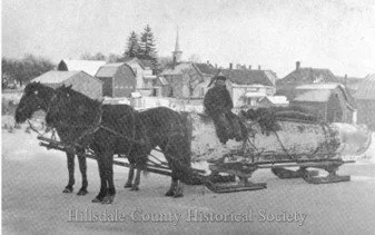
James Seely with his team of horses hauling a log in Camden in 1908. Photo Hillsdale County Historical Society
In Hillsdale County: township (population 2,088); and village (pop. 512, elevation 1,020 ft 311 m). Contribution from Hillsdale Historical Society.
Camden was founded as early as 1837 by landowner Easton Chester and his sons Orson and Nathan. The community developed around several sawmills, and a post office named Cranbrook opened on 10 August that year. The office name was changed to Camden on 7 September 1840. The name, chosen at random by drawing suggestions from a hat, was proposed by sawmill owner Easton Chester after his hometown of Camden, New York. The community was officially platted in 1867 and incorporated as a village in 1899.
Organized in 1835, Hillsdale County is named for its rolling terrain. Its early settlers, coming from the northern coastal colonies, were descended from the English Puritans who emigrated from the Old World in the 1600s. There was a wave of such settlers in the early 1800s, many traveling on the newly completed Erie Canal, and made safe by the conclusion of the Black Hawk War. They brought with them a passion for education, establishing many schools. Many were abolitionists.
Previous to 1835, this part of the country was a wilderness, covered by a dense growth of trees. Roads were non-existent. Camden was originally located on the St. Joseph River at the northern edge of the present village, until a railroad organization began buying land on higher ground to the south. By 1872, with active support from its citizenry, Camden had literally picked up and moved its village up the hill to the south. The panic of 1873 resulted in the railroad never being completed through Camden, although its proposed route continued to show on local maps for many years. Further Hillsdale Historical Society photos viewable.
Camden, Carver County, MINNESOTA
Rural township; population 959, elevation 286 m / 938ft
Camden Township, west of Minneapolis near New Germany, was organized in 1859 and probably named after Camden, New Jersey.
Camden, Minneapolis, MINNESOTA
Community in Minneapolis, Hennepin County; population 31,432
Camden lies in North Minneapolis, bounded to the east by the Mississippi River. It comprises seven smaller neighborhoods: Cleveland, Folwell, Lind-Bohanon, McKinley, Shingle Creek, Victory and Webber-Camden (known simply as Camden until 1995). It also contains the Camden Industrial Area and the Humboldt Industrial Area. Two road bridges connect Camden to Northeast Minneapolis John Campbell Bohanon, a logger from Maine, who arrived locally in 1852, made a government land claim on a heavily wooded area of 160 acres by the river. Clearing the land to grow corn, he built a pioneer home for his family and mother-in-law. Running through his property, known as Camden Place, was a creek, at the mouth of which one Rufus Farnham, who arrived in 1853, built a shingle mill; thereafter it was known as Shingle Mill Creek.
In 1887 Bohanon’s farm was taken into the City of Minneapolis, and residential and commercial development ensued. Streetcars ran to Camden from 1890 to 1954. The Camden Place Rail Bridge was built in 1905 by the Minneapolis, St Paul & Ste Marie Railroad (the Soo Line), and rebuilt in 1936; it now carries Canadian Pacific trains across the river on a single track. Camden Community today is a mix of residential and commercial spaces. It is ethnically diverse, 47% of inhabitants being Caucasian, 33.4% African-American, 11.5% Asian, 9% Hispanic, and 2.6% Native American. The area is currently undergoing a grassroots rebranding as “Camdentown”. Proposed by Houston White, a Black barbershop owner, the renaming is part of a “people-based, placemaking strategy” in which “Black joy, Black culture, Black excellence and Black ownership come together to create vibrant Black futures”. The local press described the “Camdentown” renaming as “a nod to both the area’s history and to a quirky, artistic and diverse neighborhood across the world in London with the same name”.
Camden, MISSISSIPPI
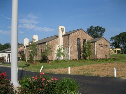
Sacred Heart Church, Camden, MS
Unincorporated community in Madison County; population 1,445; elevation 103 m / 338 ft
Located twelve miles northeast of Sharon on Mississippi Highway 17, the community was named for Camden, South Carolina by Mississippi Governor William McWillie, who was raised there and had been in the South Carolina House of Representatives and Senate. He moved to Mississippi in 1845, where he was elected to Congress, and then, in 1858, as the 22nd Governor of Mississippi. He is buried in Kirkwood Cemetery, outside of Camden.
Source: Wikipedia Camden Mississippi.
Camden, Ray County, MISSOURI
Community in southern Ray County, Missouri; population 174.
Platted in 1838, Camden is said to have probably been named after a family of early settlers. Camden Township was organized in 1841, taking its name from the community. Camden was a Missouri riverboat stop until the early 1900s, when the river's Camden bend was cut off after major river flooding, and a new channel was created to the south. A post office called Camden, opened in 1838, was closed in the early 2000s.
Camdenton, Camden County, MISSOURI
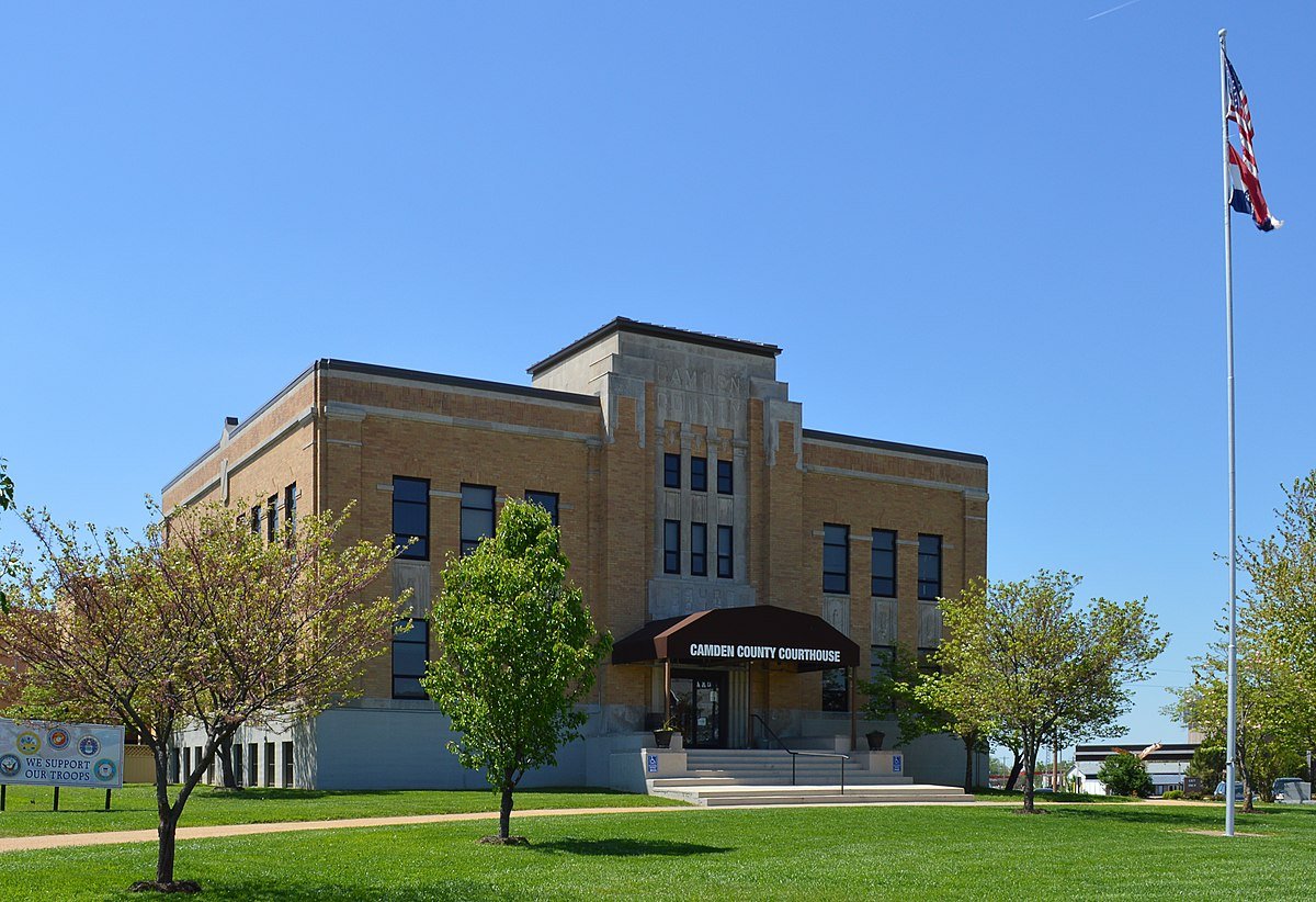
Camden County Courthouse, MO (photo: Kbh3rd, 2016)
City (population 4084, elevation 318m / 1043 ft); county (population 42,745, area 1836 km² / 709 sq mi)
Before White settlement, Camden County was the territory of the Osage and Delaware Native American tribes. The area was host to many French and Spanish explorers and traders. After the Louisiana Purchase, the first permanent white settlers were Reuben Berry and William Pogue, who came from Kentucky in 1827.
The county was organized on 29 January 1841, named Kinderhook County after the residence of President Van Buren’s residence. On 23 February 1843 it was renamed Camden County after Charles Pratt, 1st Earl Camden. The population grew steadily: in 1850 the population was over 2,300 people; by 1860 there were almost 5,000 people, 136 of them enslaved. During- the Civil War, most Camden County residents were loyal to the Union, though about 100 men from Camden County joined the Confederacy.
The huge reservoir known as the Lake of the Ozarks was created by impounding the Osage River in the northern part of the Ozarks in central Missouri. Construction of the Bagnell Dam began in 1929. During construction, the lake was referred to as Osage Reservoir or Lake Osage, and the Missouri General Assembly officially named it Lake Benton, but none of these names stuck. The lake has a surface area of 54,000 acres (220 km2) and 1,150 miles (1,850 km) of shoreline. The main channel of the Osage Arm stretches for 92 miles (148 km). The reservoir’s serpentine shape has earned it the nickname "The Missouri Dragon".
Camden County is the primary setting of the Netflix show Ozark. Among the several towns and villages permanently flooded to create the lake was the then county seat of Linn Creek, which was relocated. A new county seat was established, enveloped by the Lower Niangua arm of Lake of the Ozarks. Named Camdenton, it had its beginnings in 1931. The Camdenton Memorial Airport hosts an annual air show. The nearby Ha Ha Tonka State Park is described as a geologic wonderland featuring sinkholes, caves and a huge natural bridge. It is overlooked by the ruins of Ha Ha Tonka Castle, started in 1905 by a Kansas City businessman and burned down in 1942. The name alluded to the natural springs on the property and was said to mean "big laugh" or "smiling waters”.
Source: Wikipedia
VIDEO: Missouri Untold: the Camdenton Counterfeits, for those who can log in to Facebook.
Camden Point, MISSOURI

Camden Point Orphan School, 1877
Town in Platte County; population 462, elevation 281 m / 922 ft
Seven miles northeast of Platte City, the county seat, the town was founded by William Moore Kincaid, who moved from Kentucky in 1830. The town was initially called Camden, but the name was changed to Camden Point when Kincaid opened a post office in his home in 1837/38. According to the State Historical Society of Missouri, the name Camden was “most likely a transfer from England, perhaps via another town in the USA”. Kincaid donated $200 and 5 acres of land to help found the Camden Point Female Academy in 1848. Housed in a “large and elegant building capable of accommodating 125 boarders, it became co-educational. Surviving the Civil War, when federal troops bivouacked on its campus, it was sold to the Christian Church of Missouri and turned into a school for local children and orphans. After a fire in 1889, it relocated to Fulton, Missouri.
The Battle of Camden Point took place in 1864. A Confederate cavalry force about 200-300 strong under Colonel J C Thornton was organizing locally. On 13 July, his men held a picnic with sympathetic town residents in an open pasture near the town. Two Federal cavalry detachments commanded by Colonel Jim Ford and totaling 700-1,000 soldiers, ambushed Thornton's picnicking force, routing it and killing two and wounding around 25 Confederates. Four additional Confederates were captured and executed by Federals after the battle ended. Ammunition, weapons, and gunpowder were captured and Camden Point was burned. In 1871, a memorial to the Confederates killed in the engagement was erected at the Pleasant Grove Cemetery near the town.
Camden, NEBRASKA
Ghost town in Seward County; elevation 408 m / 1340 ft
Camden served many pioneers using the Oregon Trail cut-off to Fort Kearney. The first bridge across the Blue River was in this area, and the first post office in the county opened here in 1862. Four years later, William T. Buchanan, from Ohio, opened a store at Camden, one of the first settlements in this vicinity and when it was learned that the main line of the Burlington railroad would miss Camden, and run through Crete, he moved his store there. While at Camden he engaged in trading with the Native Americans, exchanging merchandise for the furs and pelts brought in by them. A cemetery and stone marker are all that remain of the town today.
Camden & Camden County, NEW JERSEY

The Camden - Philadelphia Bridge
City (population 73,742; elevation 5 m / 16 ft; county (pop. 506,721, area 588.7 km² / 227 sq mi).
Contribution from Camden County Historical Society
By Bonny Beth Elwell
Located along the Delaware River across from Philadelphia, Pennsylvania, the land that is now Camden County, New Jersey, was originally the home of the Lenape, the Native Americans who inhabited the Delaware Valley region. Dutch traders were the first Europeans to live in what is now Camden County, establishing the fur-trading post Fort Nassau along the Delaware River near today’s Gloucester City in 1626. Dutch, Swedish, and English vied for control of the Delaware Valley during the following decades. After the English finally gained control, they named the land “New Jersey” and members of the Religious Society of Friends in England began plans to create a Quaker community in West New Jersey for religious and economic opportunity. English and Irish Quakers arrived along the Delaware River beginning in 1675, and soon settled along Coopers Creek, Newton Creek, and Timber Creek, establishing the /beginnings of today’s Camden County.
One of the most prominent of these Quakers was a London blacksmith named William Cooper, who settled at the mouth of Coopers Creek in 1681, a site which would later become the city of Camden. By 1682, settlers were ferrying across the Delaware River from Cooper’s landing to Philadelphia, and soon the Cooper family became the primary ferry operators in this emerging transportation hub. By the early eighteenth century, most of the land that now comprises Camden City was farmed by large landowners, with the labor of indentured servants and enslaved Africans. Prominent towns in what was then Gloucester County included the county seat Gloucestertown at the mouth of Timber Creek and Haddonfield along Coopers Creek. The ferry landings provided for the exportation of goods such as timber, crops, and livestock to Philadelphia or international markets, as well as the importation of European goods. From 1727-1765, a few hundred enslaved Africans were offered for sale at the Cooper’s Ferry landings, but a growing anti-slavery movement among the Quakers led to the end of the slave trade and the beginning of the abolition movement in West New Jersey.
In 1773, Jacob Cooper (a great-grandson of William Cooper) laid out the first town streets and lots of Camden Town along Cooper Street leading to his brother Daniel Cooper’s Ferry landing. He named the town after Earl Camden, Charles Pratt, who was sympathetic towards the American colonies’ grievances at the eve of the American Revolution. With the outbreak of war, many residents joined the local militia. When the British army occupied Philadelphia from 1777 to 1778, war came to today’s Camden County. Before and after the Battle of Red Bank at Fort Mercer, British and Hessian soldiers passed through Cooper’s Ferry, Haddonfield, and Gloucestertown and skirmished with local militia. Later, the British occupied Cooper’s Ferry, plundered Haddonfield, and foraged the countryside, passing through Cooper’s Ferry one final time as they evacuated Philadelphia in June 1778.
After the American Revolution, the town of Camden expanded with the addition of more town lots in adjacent Cooper Village in 1793 and Camden Village in 1820. The town now included a post office, a state bank, and a weekly newspaper. Camden City officially incorporated on February 14, 1828. Steamboat ferries and the first railroad in 1835 expanded transportation between Camden, Philadelphia, New York City, and the entire region. Meanwhile, the Quakers of Haddonfield Meeting had ended slavery within their membership by 1792 and were actively seeking to free those still enslaved in Gloucester County. Formerly-enslaved people of color formed free Black communities, such as Snow Hill and Free Haven (today’s Lawnside) and the neighborhoods of Fettersville, Kaighnsville, and Centreville (now within Camden City). These communities also attracted freedom-seekers from the neighboring states of Delaware, Maryland, and Virginia through the Underground Railroad. German, British, and Irish immigrants also diversified Camden’s population during the mid-nineteenth century.
In 1844, Camden County was created from the portion of Gloucester County between Pennsauken Creek and Big Timber Creek, named for Charles Pratt, 1st Earl Camden; and in 1848, Camden City was voted the county seat. During the following century, the city expanded rapidly, from a population of less than 10,000 in 1850 to over 125,000 in 1950. As a transportation hub linked by ferry to Philadelphia and by turnpike and railroad to the rest of the state, Camden was ideally located for business and industry. Some of the businesses in Camden included lumber mills, woollen mills, sausage makers, carriage factories, tanneries, glass factories, blacksmiths, nickel works, cigar factories, canneries, and shipyards. After the Civil War, many Southern Black people moved north to Camden, and some were appointed to Republican leadership positions such as freeholders and policemen. Polish, Jewish, and Italian immigrants poured into Camden City to pursue the economic opportunities available in the industrialized city. Brick row homes housed the new arrivals, including Camden’s most famous resident, the poet Walt Whitman. Also located along the Delaware River, nearby Gloucester City incorporated in 1868 and greatly expanded with industry as well.
By the twentieth century, several Camden businesses had expanded to international fame, such as Esterbrook Pen Company, J.B. Van Sciver Furniture Company, Campbell’s Soup Company, and Victor Talking Machine Company (later RCA). The Delaware River Bridge (later renamed the Benjamin Franklin Bridge) opened in 1926, linking Camden to Philadelphia and greatly expanding transportation opportunities. New York Shipbuilding Company produced battleships during World War I and World War II. Southern Black and Puerto Rican people moved to Camden to work in the war industry, adding to the ethnic diversity of the city. Meanwhile, former farmland developed into suburban towns along the Camden and Atlantic Railroad, the Philadelphia and Atlantic City Railroad, and the White Horse Pike, and dozens of towns and boroughs incorporated. Easily accessible to the cities of Camden and Philadelphia by trolley, railroad, or automobile, these suburbs were attractive places to live. Once urban manufacturing jobs declined after World War II, many middle-class White families left the city for the suburbs.
By the 1970s, Camden City’s overall population had decreased, while the percentage of Black and Hispanic residents had increased. Racial unrest led to sit-ins, violence, and finally riots in 1971. White residents and businesses continued to leave the city, and by 1980, over 75 percent of the city’s population was non-White, including Black, Hispanic, and Vietnamese communities. Camden’s population continued to drop, leaving behind poverty, pollution, drugs, and crime. Meanwhile, other areas of Camden County expanded with industry, commercial buildings, and shopping malls, including Cherry Hill, Pennsauken, Gloucester Township, and Voorhees. The suburbs now dominated Camden County, but Camden City continued to serve as the seat of government as well as a center for healthcare (including Cooper Hospital and Virtua Health) and higher education (such as Rutgers University). Various programs in the twenty-first century sought to revitalize Camden City, including developing the waterfront as an entertainment and business center. Camden City continues to strive for a fresh start, with a multicultural population and hopes for the future.
In 1975, the Mayor of Camden, NJ presented a symbolic golden key to the Mayor of the London Borough of Camden (Camden Journal, 28 Nov 1975).
Camden, NEW YORK

Frisbie House, Camden NY, c.1915
Town in Oneida County (population 4,788), and village (pop. 2,169, elevation 153 m / 502 ft)
Information from Camden, New York website.
The Town of Camden was established as a political unit in 1799, when it was formed from the Town of Mexico, Oswego County. Later, the Towns of Florence and Vienna, and part of Annsville, were created from Camden. The present boundaries were established in 1864. Subsistence farming predominated until about the time of the Civil War, when dairying and cheese became important. Industry in Camden began with several sawmills, planing mills, grist mills, and other small factories along Mad River, Little River, and the West Branch of Fish Creek. The first *foundry was built in 1832 for the manufacturing of iron plows and farm tools. One of the chief articles of manufacture was turbine wat-er wheels which were sold throughout the nation. The Camden Knitting Company was active about 1900 and employed some 200 people in the manufacture of women's and children's wear. The F.H. Conant chair works, once located on the site later occupied by Rochester Shoe Tree Company, made over 100 styles of furniture. Other industries include the Camden Wood Working Company and a pencil factory. Many changes have taken place in the manufacturing in Camden during the twentieth and twenty first century.
Textiles, lumbering, and canning have lost their former places of prominence in the local economy. These industries have been replaced by wire fabricating, various wood-related industries, and a collectable stamp company. The town has only two stop lights, the second one installed in 1999.
Contained within the Town of Camden is the Village of Camden – also known as The Queen Village – which was incorporated on 2 May 1834. Its Carriage House Museum is run by the Queen Village Historical Society founded in 1970.
Camden & Camden County, NORTH CAROLINA
Contribution from Camden County Historical Society & Heritage Museum.
With a population in 2020 of 10,654, and an area 802.9 km² (231 sq. mi), Camden County lies in the North Carolina Coastal Plain between Currituck County and Pasquotank & Gates Counties. It is bordered by the State of Virginia to the north, and the Albemarle Sound to the south. Prominent and prosperous families lived on thriving plantations before 1700, and through the entire 18th century, in what is today Camden County. In 1704, four square miles of land were set aside by the Council of State as a reservation for the Yeopim Indian tribe. This site was located on the southwest side of the North River. The Mosley map of 1733 clearly indicated the Yeopim Village with a cluster of wigwams on the reservation, which included most of the present-day communities of Sandy Hook and Indiantown. The Native Americans maintained peaceful relations with their neighbors until their departure in 1774 to join the Iroquois in New York.
Old Trap, a fertile and prosperous section of Camden County, derives its name from the grogshops located here in colonial days, when rum and other items were imported directly from the West Indies to nearby harbors. Because their menfolk sometimes tarried overlong at the grogshops, the women called the place “The Trap”. Hence it came “Old Trap”. The early name of this whole area was Down River. Camden County was created on 9 May 1777, by North Carolina’s first General Assembly, out of part of Pasquotank County, with the town of Camden as its seat of government. It was named for Charles Pratt, First Earl Camden
One of the most dignified figures who played a part in Camden’s history was Isaac Gregory. He is best remembered for his valiant stand at the 1780 Battle of Camden, South Carolina (below). His services to his own state did not end with the war, He was elected once to the House of Commons and re-elected successively to the State Senate for the next eight years. In 1790, General Gregory was appointed by President George Washington to be the first collector of customs for the Port of Camden, or “Plank Bridge”, a port of entry, on Sawyer’s Creek, whose considerable maritime activity brought commercial benefits to the entire community. Joseph Jones attempted to establish a town here called Jonesboro, Wharves and warehouse dotted the banks of the creek to Muden’s Landing on the Pasquotank River. Because of the shallowness of the creek and ships of heavier tonnage being built, the once flourishing trade vanished.
Camden County contains the southern terminus of the Great Dismal Swamp Canal, which runs for 22 miles up through Virginia, eventually connecting to an inlet running into the Atlantic Ocean. Its construction began in 1793. The “golden age” of the canal was from 1839 to 1860, when hundreds of shingle flatboats, picturesque passenger ships, and freighters plied its waters. The canal now serves as a scenic waterway for pleasure craft.
Born into slavery in about 1786 was Moses Grandy. In the course of his life he would witness beatings and sales of family members, including his first bride just eight months after their marriage. Becoming a skilled waterman, he was allowed to work on the canal on his own account, although a succession of abusive masters took a cut of his earnings. Two attempts to buy his freedom failed, when his owners kept the money but continued to hold him in slavery. After four decades of enslavement, Grandy was at last sold to an honorable man and, obtaining his freedom, moved north. In 1842 he travelled to London, where he dictated a harrowing narrative of his life, which was published in support of the abolitionist cause and to raise money to buy the freedom of his still enslaved second wife and children. See Camden County website on Moses Grandy.
Grandy’s narrative was published in London in 1843 by Charles Gilpin, a Quaker and publisher of radical literature. Later a Member of Parliament, he lived and died in Bloomsbury, in today’s London Borough of Camden.

Camden County Courthouse of 1847
On 19 April 1862, a Civil War engagement called the Battle of Sawyer’s Lane was fought near South Mills, Camden County. Here, Confederate troops under the command of Colonel A.R. Wright fought Union troops attempting to blow up the Dismal Swamp Canal Locks. The Confederate commander had selected his defensive position with such care that for three hours his force withstood all Federal assaults. After a brisk battle, the Federal troops withdrew.

Camden County Jail 1910
In 2006 Camden County became the first and only consolidated city-county in the State of North Carolina, and its county seat is the Courthouse Township of Camden.. The County is divided into three townships: South Mills Township, Courthouse Township of Camden (also known as Camden Township), and Shiloh Township.
The town of Camden lies on the eastern banks of the Pasquotank River, across from Elizabeth City. With a population of 620 in 2020, it boasts five schools and two buildings on the National Register of Historic Places – the Camden County Courthouse of 1847, replacing the original wooden building which burned down and Camden County Jail (1910), its second floor restored to display the iron cellblock, or “bullpen” surrounded by a narrow catwalk. The Camden County Jail podcast provides more information.
Camden, OHIO
Village in Preble County; population 2,046 (2010), elevation 255 m / 837 ft
Information from Camden Ohio website.
Camden was originally called Dover when it was laid out in 1818, but became Newcomb in 1824 when it opened its first post office and learned there was already a Dover in Ohio. The new name never quite resonated with residents, though, so the village became Camden in 1835 and the name has remained. Camden is home to a Black Walnut Festival held annually in October.
Camden, PENNSYLVANIA
Populated place in Allegheny County; elevation 261 m / 856 ft
Camden is located within the Borough of West Mifflin, southeast of downtown Pittsburgh.
Camden, SOUTH CAROLINA

The Kershaw-Cornwallis House at Historic Camden with Revolutionary reenactors
City and county seat of Kershaw County; population 7,185, elevation 187 ft (57 m).
Contribution from the Kershaw County Historical Society.
By Joan A. Inabinet
Viewing Camden, South Carolina
In the midlands of South Carolina, Camden is an attractive, friendly, and energetic city in which a rich historical past is visibly appreciated amid modern growth, diversity, and change. Colonial development slowly followed King George II’s approval of a 1730 trade plan to attract an influx of settlers into the wilderness of interior South Carolina to buffer the port city of Charles Town (Charleston) from attacks of the hostiles among indigenous peoples. Under the plan, Fredericksburg Township was laid out in 1733 along the navigable Wateree River at the mouth of tributary Pine Tree Creek, intersecting the Catawba Indian footpath linked with native routes from the seacoast into the far interior. No town formed here though, since proposed lots lay in uninhabitable swamplands.
About 1750 a group of Irish Quakers settled on scattered plantations in the area, peacefully interacting with Catawba Indians who seasonally returned for traditional purposes. Samuel Wyly, leading man among the Quakers, and Hagler, “King of the Catawbas”, forged a strong, mutually protective bond of trust and friendship important to the settlers’ early survival. In 1758 30-year-old Joseph Kershaw, born and schooled in England, moved to Fredericksburg to establish a store at a site he called Pine Tree Hill. Having worked for several years as a mercantile clerk in Charleston, he too placed confidence in King Hagler’s friendship and protection. In 1762 Kershaw married Sarah Mathis, daughter of local Quaker settlers with ties to Philadelphia merchants, and they began a family. With Kershaw’s connections, his country store prospered along with his large property acquisitions and ambitious enterprises that processed local products, like fine milled wheat that he forwarded to Charleston markets. Certainly not the only useful individual to influence the early and following decades, Kershaw was nevertheless a long and strong thread throughout the area’s colonial and revolutionary history.
For its first decade, Pine Tree Hill was a growing frontier village with Kershaw the leading citizen in local economy and defense, and in colonial politics and influence. Numerous accounts call him “the father of Camden.”
The Naming of Camden
The renaming of Pine Tree Hill took place in an emotional and stressful period in the backcountry. In South Carolina, only one court could enforce the law, and that court was in distant Charleston. Here, in the richest city in mid-eighteenth-century America, coastal aristocratic men of wealth dominated representation in South Carolina’s single elective body of legislature, the Commons House of Assembly. Backcountry citizens, who had futilely begged for local courts and law enforcement, experienced in 1767 a reign of murder and criminal terror from bands of unchecked outlaws in the wake of Cherokee War violence. Desperate men banded together as Regulators and gathered to petition for redress of grievances, claiming themselves to be 4,000 in number who would march into the Charleston court if not heard. They got attention. In a few weeks the Assembly funded and sent out two companies of rangers for 90 days to hunt down outlaws and restore order, although other changes which had to be ratified in England took more time.
Meanwhile in Pine Tree Hill, the new name “Camden” was chosen in honor of Charles Pratt, the first Lord Camden, then popular in America as an English champion of colonial rights for representation. The name was said to have been proposed by Kershaw, a strong supporter of such principles and a rising political voice.
The Reverend Charles Woodmason, the only minister of the Church of England assigned to the backcountry, logged in his journal on July 3, 1768: “Officiated at Pine Tree Hill (now to be call’d Camden in Honor of Lord Cambden … the Americans being very fond at present of all who declar’d in their favor against the Stamp Act).”
The earliest official recognition of the name change had been recorded April 12, 1768, as part of the first legislative act calling for local courts, with one to be in Camden, “lately called Pine Tree Hill.” The act, forwarded to England, was rejected and had to be resubmitted. It would be late 1769 before the Circuit Court Act would be approved for seven district courts and courthouses, one of them in Camden, within a huge “overarching” Camden District. Joseph Kershaw that year was elected to the Assembly, a position to which he would continue to be re-elected.
A detailed plan shows that by 1774 an orderly plan influenced by Kershaw had been laid out for the Town of Camden. It included a central square through which “Broad Street” (on the old Catawba Path) ran north and south. Along that street the courthouse and the facing jail had been built (finished in 1771) beside “King Street,” with other facing spaces marked for a church and a market. Outside the eastern town limits, beside “Fair Street,” a large area was reserved for the Fair, established that year and requiring, in old English custom, its own “court of piepowder.”
On the eve of the American Revolution, Camden was transforming from backcountry pine-stump village origins into a promising, proper, law-respecting English-like town. During the Revolutionary War and afterwards, Camden underwent many changes, some destructive, but through which early vision and spirit echoed.
The Visible Past Today

King Hagler atop the town clock tower, Camden’s most familiar icon
The locations and names of the streets on the 1774 plat continue in use today, while the city has spread far outward from its early nucleus. An iconic weathervane image of King Hagler with drawn bow, an identical replica of its locally forged 1826 original, overlooks the extended Broad Street main business district from the spire of the old town clock tower. The original weathervane is displayed in the Camden Archives and Museum, where area history is researched and visited. The Wateree River west of Camden was a flowing travel route from prehistory through nineteenth century, the town being an inland river port between the ocean and the interior. Since the twentieth century, dams have restricted the river’s use to serviceable, scenic, and recreational purposes. Two environmental river parks offer access and walking trails for contact with the area’s earliest natural asset. Behind a large dam further north of Camden, beautiful 13,000-acre Lake Wateree includes residential and recreational areas.
Long ago, after Quakerism waned, the burying ground of the old meetinghouse was expanded to include other community graves. Today burials continue at picturesque Quaker Cemetery and other historic burying grounds nearby, including Beth El Jewish Cemetery and Cedars Cemetery, the latter begun for antebellum African Americans. Today entering Camden from the south and crossing Pine Tree Creek by a modern bridge, one observes on the right two significant interpretative facilities on the grounds of Joseph Kershaw’s Pine Tree Hill beginnings.

Recreation on the Wateree River, an ancient travel route to Camden
First, the recently completed Revolutionary War Visitor Center welcomes all to the Public House, with the exterior appearance of an old local inn that in historic times was a gathering place for area information. Designed as “an interpretative gateway to South Carolina’s pivotal role in the American Revolution,” the Visitor Center inside maintains lively displays explaining “the real turning point in the Revolution—the Southern Campaign.” Its two additional structures, Liberty Hall and the Market Building, provide indoor and open-air spaces for speakers and programs. Next, on more than 100 acres of the original town, Historic Camden Foundation’s Revolutionary War Site, affiliated with the National Park Service, fulfills the mission “to protect, educate and celebrate Camden’s extraordinary Colonial and Revolutionary War history.” Historic Camden’s park has been developing since 1966 as an outdoor museum of backcountry life with seven preserved houses, fortification sites, miles of nature trails, and living history demonstrations of crafts, trades, and diverse lifestyles through the early federal period. The Kershaw County Historical Society lately donated a restored 1812 house built by an enslaved craftsman who by his labors purchased his own freedom.
Historic Camden also boasts a significant Revolutionary reconstruction on archaeologically excavated foundations and study of the house’s nineteenth-century images. In 1780 the home of Joseph Kershaw and family, a newly constructed Georgian manse on a hill overlooking the early town, was seized and fortified by the British commander in the south, General Charles, Lord Cornwallis. For almost a full 12 months, the house served as the primary British headquarters in the backcountry. The house was burned in 1865 when Union troops under General William T. Sherman invaded Camden during the American Civil War. The reconstruction, with appropriately elegant furnishings of period antiques, includes also meeting and interpretative areas. Besides these assets, about eight miles northward, Historic Camden Foundation owns over 500 acres of the site of the 1780 Battle of Camden. Here HCF maintains a growing longleaf pine preserve and works closely with Kershaw County, the City of Camden, the South Carolina Battleground Preservation Trust, the American Battlefield Trust, and the Liberty Trail. With approach of the 250th observation of the independence of the United States of America, many are the stories to be unfolded during its Sestercentennial so that the roots of the country’s founding and its participants can be better understood.
Revolutionary Beginnings
Although at a far distance from the firing of the first guns of the American Revolution in Massachusetts in April 1775, the South Carolina backcountry stirred with civil unrest, neighbor disputing neighbor over allegiances. Joseph Kershaw travelled through interior South Carolina explaining American (“patriot”) issues and listening to British (“loyalist”) sympathizers. In 1776 British ships attempted to gain a foothold to prized Charleston, but were repelled June 28 at Sullivan’s Island, the first decisive patriot victory over the Royal Navy. On the Carolina frontier, the British-allied Cherokee Indians rose up again on July 1, adding several months of additional concerns to patriot-loyalist tensions. Kershaw remained in contact with the Catawbas, who supported the patriots.
Again in 1780 Charleston was targeted as the British launched their Southern Campaign to bring about a quick and favorable end to the war. Already in control of Savannah, Georgia, the British believed that loyalist support in the Carolinas would sweep them to victory. With a different plan to capture Charleston, troops of Cornwallis and Lieutenant General Henry Clinton, commander of North America, crossed swamps and rivers to cut off the peninsula and to besiege what was effectually the whole American army in the South, bottled up at Charleston. After six weeks of unsupplied resistance, March 29 to May 12, Major General Benjamin Lincoln was forced to surrender the battle-scarred city and army of over 5,000 defenders. It was a major British victory.
Too many men having been captured to imprison then all, many were sent home on parole upon signing pledges, on penalty of death, not to take up arms against the King again. Only days after the capture of Charleston, Cornwallis headed his men 130 miles inland to occupy Camden on June 1 and establish it as his main backcountry garrison and supply depot, fortifying it with redoubts and a palisade wall, and setting up headquarters in the Kershaw house. Sarah Kershaw and their young children would soon have to move to the countryside. Faithful slaves were among those helping protect the family there. African Americans were choosing allegiances on both sides, for the British offered freedom from slavery to those allying with them. Placed under arrest at the fall of Camden, Kershaw as a militia colonel and a legislator had value to the British as a potential swap in a prisoner exchange, but his influence close at hand was feared. He was shipped in exile with his brother Ely and others of influence on prison ships to British Honduras, then to Bermuda, his brother dying from fever on the way. The initial successes of the British military in imposing their control in the south may have been effective, but they did not call forth the expected enthusiasm of appreciative loyalists eager to join the King’s cause. In fact, the more people were pressured to join, the more they resisted.
The Battles of Camden
The resistance was such that over 200 battles, with additional skirmishes and engagements, were fought within South Carolina during the American Revolution, more than in any other state. Within 25 miles of Camden, some of the battles were Cary’s Fort, Radcliffe’s Bridge, Rugeley’s Mill, Flat Rock, Beaver Creek, and Hanging Rock. The two battles most closely identified with the town’s name itself were the 1780 Battle of Camden and the 1781 Battle of Hobkirk’s Hill, sometimes called the Second Battle of Camden. That second battlefield lies inside the present city limits, on an elevation now noted for the well-preserved nineteenth-century homes that cover its ground.
For Americans the most devastating battle of the entire war, the Battle of Camden, resulted in a tremendous victory for the British. Fought early in the campaign, the battle on August 16, 1780, engaged 3,700 Americans and 2,230 British, with estimated casualties being very one-sided: 1,900 Americans, 324 British. In the heat of July, American Major General Horatio Gates had begun marching down from the north with an army of continental soldiers and militiamen collected along the way on the mission of freeing South Carolina. Upon hearing of the approach of the hero of the British defeat at Saratoga, New York, which had prompted France to ally with America, Cornwallis acted quickly. He immediately left Charleston and set out for Camden, determined to meet Gates on the field. In the dark of early morning, August 16, 1780, with neither army aware that the other was on the move, they came upon one another unexpectedly in the pine forest of Gum Swamp. Briefly skirmishing, then forming for battle, Gates has been said to have erred in placing his men, putting his least experienced Virginia militiamen on the right, facing the most experienced of Cornwallis’s veteran regiments. When the British advanced with fixed bayonets, the militiamen, in frontier-fighting reaction, turned and fled, carrying the rout to North Carolina militia at the middle of the line, which collapsed. Maryland and Delaware Continental Regulars stood fighting on the field as Gates and others fled, pushed backward on a narrow road in the swarm of disorderly retreat. Among the casualties overwhelmed while fighting on the field was Major General Johann de Kalb, with 11 wounds. He died several days later in Camden. On the battlefield a marker stands where he fell, and in Camden a stately memorial was later erected, its cornerstone ceremoniously laid in 1825 by General Gilbert du Motier, Marquis de Lafayette.
After the Battle of Camden, Gates was replaced in command by Major General Nathanael Greene, who also approached Camden in 1781 with intent to end British control of South Carolina. The Battle of Hobkirk’s Hill, or Second Battle of Camden, thus ensued. Finding the defenses of then commanding Colonel Francis, Lord Rawdon too strong to attack, Greene established his camp on a high ridge overlooking Camden and waited for Rawdon to approach him at that favorable site of his choosing. Rawdon on April 25 made a side approach, however, and first engaged at another point. Despite some confusions, Greene was able to use and save his artillery, inflict injuries, and withdraw in orderly manner. Greene brought a force of 1,550 men whom Lord Rawdon faced with 900. Action concluded with 270 American casualties (19 killed) and 258 British casualties (38 killed). Although he had driven Greene away, Rawdon two weeks later evacuated Camden on May 9 because the cutting of his supply lines and persistent attacks were severe threats to his ability to defend his position and his men. When the British left Camden, burning what they could behind them, they retreated to Charleston, accompanied by a long line of dismayed loyalists and families with their possessions, many taking slaves with them, all waiting to learn what lay ahead.
Patriots at war’s end had similar uncertainties looking at its scars left behind, but many faced the challenges optimistically, ready to bind wounds. Exchanged from exile near war’s end, Joseph Kershaw returned to Camden. In Bermuda he had on his own mortgaged his American properties to Bermuda merchants to aid the American cause. Kershaw spent the rest of his life helping rebuild his community and selling off his holdings to pay debts to his creditors. In 1791 the newly formed county, of which Camden was the seat, was named Kershaw County in his honor. The name was in use when he died December 28 of that year at 64 years of age.
Continued Legacies

Horses, early used for travel, enjoyed in Camden’s Carolina Cup steeplechase
Over the passage of time, through common trials and aspirations, America and England have stood together as allies. In June 1941 Camden warmly welcomed the first 65 of 300 Royal Air Force cadets, who, needed as pilots in defense of their homeland, were sent to train to fly at the new Southern Aviation School at the Camden Airport. Soon American trainees too would join them in the skies of World War II. When the aviation school closed at the end of the war, its buildings beside the airport were purchased in 1950 to open a private school for young men.
Camden Military Academy, begun by Col. James F. Risher as president, was administered for 37 years by his son, the first headmaster, Col. Lanning P. Risher, both of them men of history and tradition. In awareness of the origin of the Camden name and of the buildings having schooled RAF pilots, permission was sought and received from the contemporary Lord Camden to use the Camden coat of arms for the academy’s identification. Thus the first dress uniform caps, as well as those worn by present cadets of today’s Camden Military Academy, prominently display the brass seal formed from that coat of arms.
Modern Camden and Kershaw County in many ways continue proud legacies of spirit and personality, where architecture and nature are appreciated, a variety of arts and equestrian sports are enjoyed, and community members pitch in to support worthwhile projects and respect the freedoms of their heritage.
Links for more detail and views of Camden, South Carolina
Camden Archives & Museum
Visitor Guides to Camden and Kershaw County
Revolutionary War Visitor Center at Camden
Historic Camden Foundation
The Kershaw County Historical Society
S.C. American Revolution Sestercentennial Commission
South Carolina Battleground Preservation Trust
American Battlefield Trust
The Liberty Trail
African American Cultural Center of Camden
Native American Studies Center at Lancaster
Downtown Camden Cultural District
The Arts Center of Kershaw County at Camden
The National Steeplechase Museum at Camden
The Carolina Cup at Camden
Kershaw County Government
Camden, TENNESSEE
City in and county seat of Benton County; population 3,674, elevation 137 m / 449 ft
Native Americans were living in the Camden area as early as 8000-1000 BC. A significant archaeological site has been excavated at nearby Eva (the actual site is now submerged under Kentucky Lake), uncovering evidence of semi-permanent habitation dating back 7,000 years. The first European settlers arrived in the Benton County area around 1818, shortly after (and probably before) the county was purchased from the Chickasaw. Camden has its roots as a stopover along the stagecoach route between Nashville and Memphis. Initially known as Tranquility, the community was called Camden by the 1830s, a name influenced by the Revolutionary War-era Battle of Camden. When Benton County was created in 1835, Camden was chosen as the county seat. The City of Camden was officially incorporated in 1838. Agriculture is important to the economy of Camden and Benton County. Sorghum was once a key crop; the last sorghum processing facility closed in 2001. Jones Plastic and Engineering operates a large facility in Camden. The city is a bedroom community for employees of the Tennessee Valley Authority, and the DuPont titanium dioxide production plant in nearby New Johnsonville. Source Wikipedia Camden Tennessee.
Camden, Gregg County, TEXAS
Ghost town in Gregg County
On the south bank of the Sabine River, Camden grew around a river crossing known as John Walling’s Ferry. Mr Walling arrived in Texas in the early 1830s. During the early years, the names Camden and Walling’s Ferry were used interchangeably: the postmaster would accept either address. An entrepreneur named Enoch Hays built an eight-room hotel, but by the 1860s the community was in decline. The river bottom harboured mosquitoes and the populace was under constant threat of malaria, and residents fled to higher ground. A veritable ghost town by the 1870s, Camden was erased from maps long before the end of the century. Fallen tombstones remain today in its former cemetery.
Camden, Polk County, TEXAS

Locomotive on the Moscow, Camden & San Augustine Railroad
Unincorporated community; elevation 91m / 299 ft
Situated at the junction of Farm to Market Roads 942 and 62, eighty miles north-northwest of Beaumont, and tucked away amid pinewoods, Camden was one of the last sawmill towns in Texas. It was begun by W.T. Carter & Brother who, when their previous mill at nearby Barnum burned down in 1898, moved their operations to Camden. A 7-mile standard-gauge railroad was built, connecting the sawmill with the Union Pacific mainline at Moscow. Camden was named either for Camden, New Jersey, the hometown of T.H. Woodson, the town’s surveyor, or after Camden, Maine , with which the early Carters were thought to have connections. Camden, Texas, was a company town, and almost all the housing was built by the firm. The benevolent Carter family provided rented homes for its employees, a community school, a baseball field, gardens, electricity, water and a commissary store for all their household needs.
In 1968 the Carters sold their business to Champion Paper, who kept the sawmill going, as well as the railroad too (although passenger services ended in 1973). But the new owners had no interest at all in the company town. The 600 or so inhabitants were -relocated to ‘better houses’ a few miles away, and almost all the housing was demolished. After a few months, all that remained were a post office, the paper company offices and a few vacation homes. Camden had all but vanished.
Camden, VIRGINIA

Camden VA in 1980
Plantation and house in Caroline County; elevation 80m / 262ft
The plantation and house known as Camden are situated on the Rappahannock River just downstream of Port Royal. The property was bought in 1785 by a certain John Pratt. Though he may have named the property after his prominent namesake, there is no evidence that he was related to Earl Camden, several quite distinct English Pratt families having settled in America. Declared a National Historic Landmark in 1971, the present house was built on the basement of an earlier house dated to 1760. William Carter Pratt demolished it around 1856 and engaged Baltimore architect Norris G. Starkweather to rebuild it in an Italianate style.
Completed in 1859 with all mod cons, the house was equipped with central heating and cooling, gas lights and running water; a private gas works was installed to generate the gas. The house's tower was destroyed during the Civil War by a hit from a Union gunboat in 1862, and never restored.
The plantation contains the site of a 17th-century Native American community, where iron trade tools and silver medals have been found. The silver medals were minted by the British and given to the Powhatan chiefs as tokens of peace.
Camden, WASHINGTON
Populated place in Pend Oreille County; elevation 600 m / 1,968 ft
Situated in the scenic northeast corner of Washington State, between Elk and the Chain Lakes. Opened here in 2009, on a donated property, was the Camden Station of South Pend Oreille Fire & Rescue,of which there is a virtual tour.
Camden, WEST VIRGINIA
Unincorporated community in Lewis County; elevation 336 m / 1102 ft
Located on US Highway 33, 5½ miles (8.9 km) west-northwest of Weston, and with a post office. It was named after Johnson Newlon Camden, oilman, industrialist and twice a United States Senator from West Virginia between 1881 and 1895.
Camden-on-Gauley, WEST VIRGINIA
Town in Webster County; population 126, elevation 615m / 2018 ft
The community likewise derives its name from Senator Johnson Newlon Camden, who was the proprietor of several businesses on the nearby Gauley River. The town was originally called Lanes Bottom but was renamed Camden-on-Gauley when incorporated in 1904.
Canada
Camden, Nova Scotia
Community in Colchester County, south of Harmony; elevation 182 m / 597 ft
Camden Township, Ontario

Josiah Henson House (photo: NearEMPTiness, 2014)
Historic township in Kent County; area 164 km2 / 63 sq mi
Containing some of the best farmland in Ontario, the township was conceded by treaty in 1790, surveyed for settlement in 1794 and named for Charles Pratt, Earl Camden. When, in 1998, Kent County was superseded by the single-tier authority of Chatham-Kent, the township ceased to exist.
Near Dresden (population 2,800), in the former Camden Township and in a bend in the Sydenham River, is the open-air Josiah Henson Museum of African-Canadian History, previously called Uncle Tom’s Cabin Historic Site. Born into slavery in 1789, in Maryland, Josiah Henson escaped from Kentucky in 1830 with his wife and four children, and after an arduous journey arrived in Ontario.
In 1842, with Hiram Wilson, a White abolitionist, he established the British American Institute, a school providing education and training in practical skills Black Canadians at Dresden; and the Dawn Settlement, intended to be a self-sufficient community of fugitive formerly enslaved people, and exporting black walnut lumber to the US and Britain. Becoming literate and ordained Methodist minister, Henson was the settlement’s spiritual leader. He returned several times to the USA, acting as a ‘conductor on the ‘Underground Railroad’, the network of safe houses and clandestine routes used by escaping enslaved people, and of which Dresden was an important ‘terminus’.

Rev. Josiah Henson
His autobiography is believed to have inspired Harriet Beecher Stowe’s 1852 anti-slavery novel, Uncle Tom’s Cabin, which after the Bible was the 19th century’s best-selling book. Henson became known as the ‘Original Uncle Tom’. In 1876, in his eighties, he visited England with his wife, speaking in chapels all over London, raising funds for Black communities in Canada, and meeting Queen Victoria at Windsor Castle.
His house at Dresden, where he died aged 93, has been restored as part of the open-air museum on the Dawn Settlement site. Source: Wikipedia on the Josiah Henson Museum of African-Canadian History.
Camden East, Ontario

The limestone building that housed a series of general stores (photo: kermitchemist, Creative Commons, 2019)
Village in the municipality of Stone Mills, Lennox & Addington County; population 306, elevation 130 m / 427 ft
The community was originally called Clark’s Mills. Samuel Clark had moved his sawmill here, adding a wool mill and a grist mill. In 1832, the post office was built. The place name changed to Camden East, after the township was organized in 1787, and named in honour of Charles Pratt, Earl Camden. In its heyday the town of Camden contained four hotels and several stores, mills, a carriage factory, a cheese factory, carpenters, cabinet-makers, saddlers, tanners, shoemakers, tailors, bakers, tinsmiths and a fanning-mill maker. However, since the closure of the mills in the 1950s, the village’s population has significantly decreased. The wider Township of Camden (East), named in 1805, was abolished in 1998 and is now in the municipality of Stone Mills.